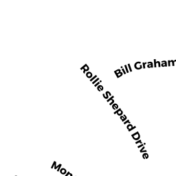
9 ROLLIE SHEPARD DR
Owner Information
TEIXEIRA JOSEPH R
9 ROLLIE SHEPARD DR
MILLBURY, MA 01527


Property Details
9 ROLLIE SHEPARD DR is classified as a Single Family Residential (Colonial).
The primary structure on this property was built in 1999. There are 5088ft2 of built area within this property. There is 2370ft2 of residential/living space within this property. This property is listed as having 8 rooms.
9 ROLLIE SHEPARD DR is valued at 384100. The land is valued at 81400 and the structures are valued at 300100. There is an additional valuation of 2600 on this property.
The most recent deed for 9 ROLLIE SHEPARD DR is recorded at the local registrar in Book 42875, Page 0124. 9 ROLLIE SHEPARD DR was last sold on 2008-05-23 for 373478.
Assessment data from fiscal year 2022.
Flood Data
According to the FEMA National Flood Hazard Layer, this property does not appear to be in a flood zone. It may also be in an area not yet reviewed. Nonetheless, confirm this information prior to taking any action.
To view the flood hazards around this property, create a FEMA "Firmette" Map of the area around 9 ROLLIE SHEPARD DR.
Broadband Internet Providers
| Provider | Type | Bandwidth (mbps) | |
|---|---|---|---|
| Verizon New England Inc. | Fiber | 940 | 880 |
| VSAT Systems, LLC. | Satellite | 2 | 1 |
| HughesNet | Satellite | 25 | 3 |
| GCI Communication Corp. | Satellite | 0 | 0 |
| Viasat Inc | Satellite | 100 | 3 |
| Verizon New England Inc. | DSL | 10 | 1 |
| Charter Communications Inc | Cable | 940 | 35 |
Broadband service provider data from December 2020.
Adjacent Properties
- 11 ROLLIE SHEPARD DR
Single Family Residential owned by WINSTON LYNN M - 1 BILL GRAHAM LN
Single Family Residential owned by COLLINS LEROY W - 3 BILL GRAHAM LN
Single Family Residential owned by NOZZOLILLO GINA M - MACARTHUR DR
Undevelopable Residential Land owned by TPR HOMES LLC - 7 ROLLIE SHEPARD DR
Single Family Residential owned by NGUYEN THOMAS H